The race track has ups and downs due to the structure of Pamukkale and the Ancient City of Hierapolis. There are direction umpires, lanes and signs in the necessary places along the entire course. You can complete the race by following the signs related to your own track. All the tracks have the last 2 km of cobblestones (paving stones) inside the Ancient City. The remaining parts of all the tracks are made of asphalt, it is recommended to choose shoes suitable for road running.
The approximately 5.6 km course winding around Pamukkale and the Ancient City of Hierapolis is a road running route characterized by significant climbing. The total elevation gain is approximately 140 meters. While the course includes some short descents, its most notable ascent is the “Foton Climb Stage,” situated roughly between the 2nd and 3.6th kilometers.
New This Year: Foton Climb Stage
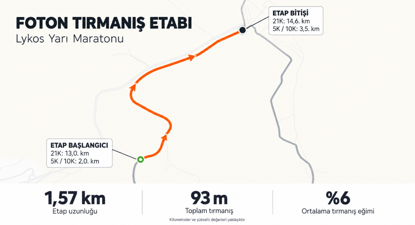
This year, Foton Climb Stage awaits participants across all Lykos Half Marathon courses.
This special section of the race course is 1.57 km long and involves a total ascent of approximately 93 meters. The average incline is 6%. On the 5K course, the stage begins at approximately the 2nd kilometer and ends at the 3.6th kilometer.
Sponsor prizes will be awarded to the top 3 women and top 3 men across all courses who complete the climb stage in the fastest time.
Surface and Footwear Selection
The majority of the course consists of asphalt surfaces. The final 2 kilometers pass along narrow, stone-paved paths within the Ancient City of Hierapolis. It is recommended to wear road running shoes suitable for both asphalt and stone surfaces.
Movement Within the Ancient City
You may choose to slow your pace and enjoy the ancient city during the final section. Due to the narrowness of the paths, participants who are running slowly or walking must keep to the right, leaving the left side open for faster runners to pass. Please be mindful of other participants when overtaking.
Course Signage
Directional signs, race officials, lane markers, and traffic cones are positioned along the route. At points where the courses diverge, please follow the signs for the 5K course and heed the instructions of the race officials.
Water Stations
There is a water station on the 5K course at approximately the 3.6-kilometer mark, at the end of the Photon Climb Stage.
| Kilometer | Water Station |
| 3.6 km | Station at the finish of Foton Climb Stage |
Course Duration and Time Limit
The time limit (cut-off) for the 5K is 2 hours from the race start time.
Athletes who continue running on the course after this time do so at their own risk. Athletes must obey traffic rules and remain vigilant regarding vehicle traffic.
Course Map
You can familiarize yourself with the route and plan your race strategy by reviewing the map and elevation profile below prior to the race.
Distance and elevation figures are approximate.
The approximately 10.1 km course, winding around Pamukkale and the Ancient City of Hierapolis, is a road running route featuring both ascents and descents. The total elevation gain is approximately 174 meters. The course’s notable climb is the “Foton Climb Stage,” located between the 2nd and 3.6th kilometers.
New This Year: Foton Climb Stage
This year, Foton Climb Stage awaits participants across all Lykos Half Marathon courses.
This special section of the race course is 1.57 km long and involves a total ascent of approximately 93 meters. The average incline is 6%. On the 10K course, the stage begins at approximately the 2nd kilometer and ends at the 3.6th kilometer.
Sponsor prizes will be awarded to the top 3 women and top 3 men across all courses who complete the climb stage in the fastest time.
Surface and Shoe Selection
The majority of the course consists of asphalt surfaces. The final 2 kilometers pass through narrow, stone-paved roads within the Ancient City of Hierapolis. It is recommended to wear road running shoes suitable for both asphalt and stone surfaces.
Passing Protocol Within the Ancient City
You may wish to slow your pace in the final section to enjoy the ancient city. Due to the narrowness of the roads, participants who are running slowly or walking must keep to the right, leaving the left side open for faster runners to pass. Please be mindful of other participants when overtaking.
Course Signage
Directional signs, race officials, lane markers, and traffic cones are placed along the route. At points where the courses diverge, please follow the signs for the 10K course and heed the instructions of the race officials.
Water Stations
There are two water stations on the 10K course. You can obtain water from the station at the 3.6 km mark on both the outbound and return legs. This allows you access to water at three points during the race:
| Kilometer | Water Station |
| 3.6 km | First station — outbound |
| 5.8 km | Second station |
| 8.0 km | First station — turnaround |
Course Duration and Time Limit
The time limit (cut-off) for the 10K is 2 hours from the race start time.
Athletes who continue running on the course after this time do so at their own risk. Athletes must obey traffic rules and remain vigilant regarding vehicular traffic.
Course Map
You can familiarize yourself with the route and plan your race strategy by reviewing the map and elevation profile below prior to the race.
Distance and elevation figures are approximate.
The approximately 21.1 km course, winding around Pamukkale and the Ancient City of Hierapolis, is a road running route featuring both ascents and descents. The total elevation gain is approximately 268 meters. Significant climbs are concentrated between the 9th and 11th kilometers and within the Foton Climb Stage, located between the 13th and 14.6th kilometers.
New This Year: Foton Climb Stage
This year, Foton Climb Stage awaits participants across all Lykos Half Marathon courses.
This special section of the race course is 1.57 km long and involves a total ascent of approximately 93 meters. The average incline is 6%. On the 21K course, the stage begins at approximately the 13th kilometer and ends at the 14.6th kilometer.
Sponsor prizes will be awarded to the top 3 women and top 3 men across all courses who complete the climb stage in the fastest time.
Surface and Footwear Selection
The majority of the course consists of asphalt surfaces. The final 2 kilometers pass through narrow, stone-paved roads within the Ancient City of Hierapolis. It is recommended to wear road running shoes suitable for both asphalt and stone surfaces.
Movement within the Ancient City
You may wish to slow your pace in the final section to enjoy the ancient city. Due to the narrowness of the roads, participants who are running slowly or walking must keep to the right, leaving the left side open for faster runners to pass. Please be mindful of other participants when overtaking.
Course Signage
Directional signs, race officials, lane markers, and traffic cones are positioned along the route. At points where the courses diverge, please follow the signs for the 21K course and heed the instructions of the race officials.
Water Stations
There are four water stations on the 21K course. You can obtain water from the stations at the 4.0 km and 14.6 km marks on both the outbound and return legs. This provides access to water at six points throughout the race:
| Kilometer | Water Station |
| 4.0 km | First station — outbound |
| 8.4 km | First station — return |
| 10.7 km | Second station |
| 14.6 km | Third station — outbound |
| 16.8 km | Fourth station |
| 19.0 km | Third station — return |
Course Duration and Time Limit
The time limit (cut-off) for the 21K race is 3 hours from the race start time.
After the start of the 21K race, the course will be gradually opened to vehicle traffic. The time limit for the 11 km mark is 1 hour 30 minutes. Athletes who continue running on the course after this time do so at their own risk. Athletes must obey traffic rules and remain vigilant regarding vehicle traffic.
Course Map
You can familiarize yourself with the route and plan your race strategy by reviewing the map and elevation profile below prior to the race.
Kilometer and elevation figures are approximate values.
Lykos Yarı Maratonu © 2025